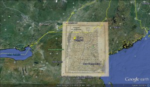
This week, our task was to overlay an older map on top of a Google Earth image. I chose a map of Vermont and New Hampshire from the New York Public Library website because I was born and raised in Vermont (as you will see in my screenshot, there is a little yellow thumbtack for “Home” over the state that I don’t ever remember putting there, but must have done at some point).
I thought this would be a pretty easy thing to do, but it’s really not. I was so distracted by all of the other stuff on both maps that it was really difficult for me to line up the image properly. It’s kind of a shoddy job but I think it’s in the ballpark; I used Lake Champlain as my marker and tried to get the two images as close as I could. Then I checked the state lines to see if they were acceptably aligned as well.
I tried to pull the whole thing up in Google Maps but it wouldn’t show the image of the older map so I just took a screenshot and posted it here as an image.

Hola! I’ve been reading
your blog for a while now and
finally got the bravery to go ahead and give you a shout out from Houston
Texas! Just wanted to say keep up the great work!